Pavilniai Regional Park & Pūčkoriai: Wild Vilnius Within the City
A guide to Pavilniai Regional Park in eastern Vilnius: the Vilnia river valley, the 65-metre Pūčkoriai exposure, the Belmontas waterfalls and a half-day of trails without leaving greater Vilnius.
- ✓Pavilniai is wild nature inside the city limits — the Vilnia river carves a steep, forested valley just east of the Old Town.
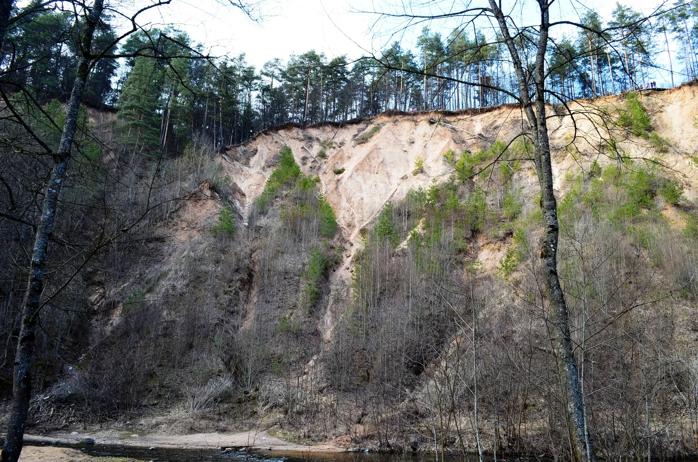
- ✓The star is the Pūčkoriai exposure, a roughly 65-metre sand cliff that is the tallest such outcrop in Lithuania, with a viewing deck over the river bend.
- ✓The Belmontas corner adds artificial waterfalls, an old water-mill site and a restaurant complex — an easy, scenic place to start or finish a walk.
- ✓The 5 km Pūčkoriai cognitive trail links the highlights at a gentle pace, with bridges, boardwalks and forest paths.
- ✓It is free, reachable by city bus, and close enough that you can fit it around a normal Vilnius day rather than blocking out a whole one.
A nature half-day without leaving Vilnius
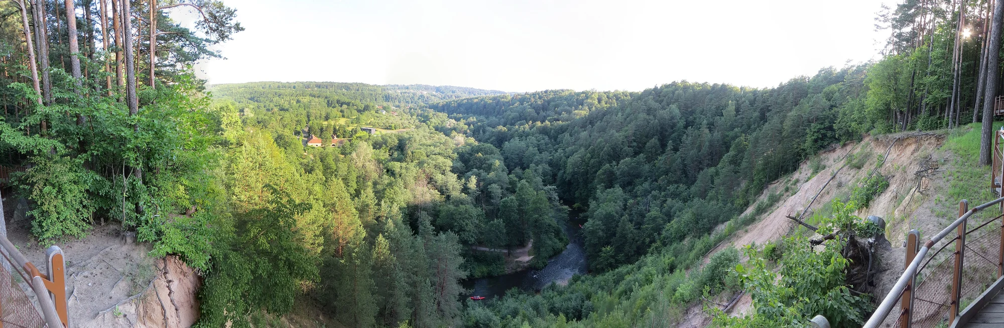
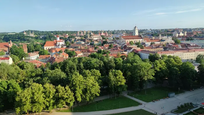
Pavilniai Regional Park is the surprise in Vilnius's back garden. Where Verkiai spreads across the city's green northern edge, Pavilniai protects the dramatic valley of the Vilnia river to the east — a sudden, steep, forested landscape that feels far wilder than its location suggests. You can be standing on a 65-metre cliff above a meandering river barely twenty minutes from the cathedral, and that contrast is the whole appeal.
Established in 1992 and covering around 2,100 hectares, the park exists to protect that river valley: the bluffs, the exposed geology, the springs and the woodland that the Vilnia has cut through over millennia. It is not a manicured city park but a genuine slice of nature, and it rewards walkers who like a bit of up and down and a proper view at the top.
Because it sits inside greater Vilnius, Pavilniai is the easiest 'day trip' on the list — one you can do on a free morning, around lunch, or as a romantic late-afternoon walk, without committing to a bus station or a long transfer. Treat it as a half-day in nature that happens to be a short hop from the centre.
It is worth knowing that Pavilniai and Verkiai are administered together as a pair of sister regional parks, each protecting a different river: Verkiai guards the Neris valley to the north, Pavilniai the Vilnia valley to the east. Between them they ring a large part of the city in protected green, which is part of what gives Vilnius its unusual reputation as one of Europe's greenest capitals. Pavilniai is the more rugged of the two — less manor and lake, more cliff and gorge — and that wildness is its character.
The two anchors are the Pūčkoriai exposure, the geological showpiece, and the Belmontas corner, with its waterfalls and mill. Link them along the river and you have a complete, satisfying loop. Everything else — the boardwalks, the river crossings, the quiet stretches of forest — strings naturally between those two points, so you never really need a map beyond the marked trail.
- Best for: walkers wanting a real view, photographers, and couples after a scenic stroll.
- Time needed: 2–3 hours for the main loop; longer if you linger at Belmontas.
- Season: best spring through autumn; expect mud after rain and ice on the slopes in winter.
The Pūčkoriai exposure — the tallest cliff in Lithuania
The Pūčkoriai exposure is the reason most people seek out Pavilniai. It is a steep, raw cliff face of sand and clay rising roughly 65 metres above the Vilnia — the tallest exposure of its kind in Lithuania — laid bare where the river has cut into the valley wall. From the observation deck at the top, the view opens over the river bend, the wooded slopes of the park and the old Pūčkoriai manor and foundry site below. It is one of the most genuinely dramatic natural sights anywhere near the city.
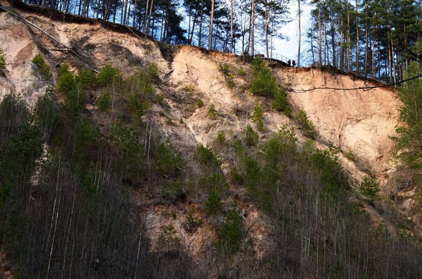
Reaching the deck is part of the fun. Most walkers come along the river from the Belmontas side and climb up through the forest, or descend to the deck from the upper approach near S. Batoro Street. Either way it is a short, rewarding effort rather than a serious hike, and a sundial stands near the exposure on the riverbank as a marker. Mind your footing near the edge — the cliff is unfenced in places and the sandy ground is loose.
This is a spot to time well. Late afternoon and golden hour light up the cliff and the river, and the deck is a favourite with photographers for exactly that reason. Bring a camera and a little patience for the climb.
There is history layered into the view as well as geology. Below the exposure stand the remains of the Pūčkoriai manor and a former gunpowder mill and cannon foundry — the source of the name, from the old word for a gunsmith — that once used the Vilnia's power. So the panorama from the deck takes in not just a dramatic natural cliff but the faint traces of an industrial past, all of it now softened back into forest. It is a genuinely rich little spot for somewhere you can reach on a city bus.
- Roughly 65 metres high — the tallest exposure in Lithuania, with a viewing deck over the Vilnia.
- Reach it on foot from Belmontas along the river, or from the upper approach near S. Batoro Street.
- Take care near the unfenced edge; the sandy ground is loose underfoot.
Map pins
Map data © OpenStreetMap contributors · Tiles © OpenFreeMap
Belmontas: waterfalls, the old mill and a place to refuel
At the lower, western end of the valley sits Belmontas — the most developed and most accessible corner of the park. Here the Vilnia powers a set of historic artificial waterfalls beside the site of an old water mill, and the surrounding complex has grown into a restaurant and events venue set among the rocks and trees. It is the one place in Pavilniai where you can sit down for a meal or a coffee, which makes it the obvious start or finish for a walk.
The waterfalls themselves are modest but genuinely pretty, especially after rain or snowmelt when the river runs high, and the rocky, wooded setting feels a world away from the city. Families like Belmontas because the lower paths are easy and there is somewhere to eat; walkers like it because it is the gateway to the trail up to Pūčkoriai.
A natural rhythm is to arrive at Belmontas, take in the waterfalls and the mill, then follow the river upstream and climb to the Pūčkoriai deck before looping back. That way you bookend the scenic walk with the one spot that has facilities.
- Belmontas has the park's only real food-and-drink option, plus the waterfalls and old mill site.
- Easy lower paths make it the family-friendly end of the valley.
- Use it as the trailhead for the walk up to the Pūčkoriai exposure.
Trails and how to walk them
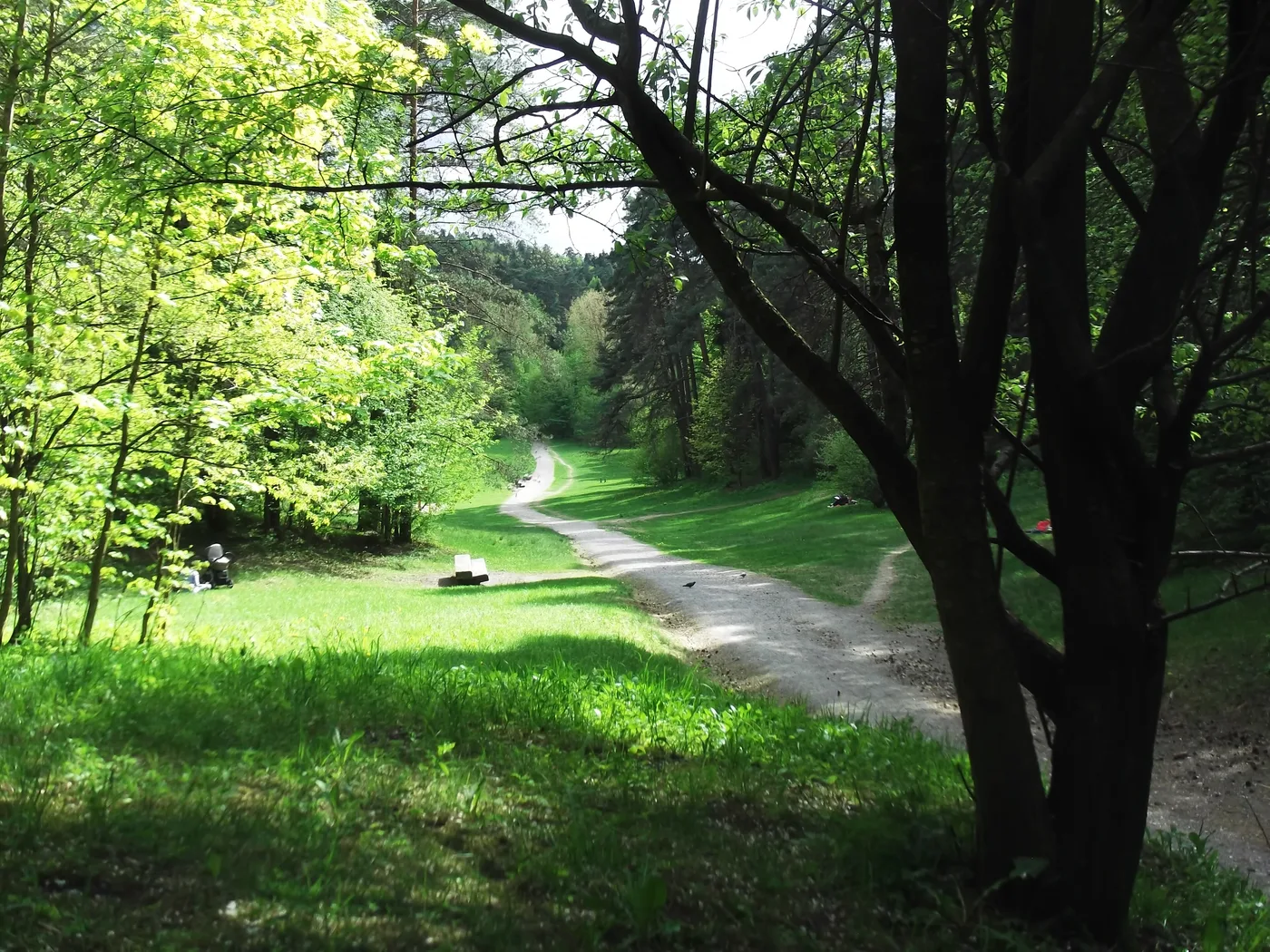
The signature route is the roughly 5 km Pūčkoriai cognitive trail, a marked loop that strings together the valley's best bits — river crossings, boardwalks, forest paths and the climb to the exposure deck. It is the simplest way to see the highlights without planning your own route, and information boards along the way explain the geology and history as you go.
Most walkers start from the parking and facilities at the Belmontas end, follow the Vilnia upstream, cross a bridge and climb to the Pūčkoriai observation deck, then return on the opposite bank. Allow two to three hours at an easy pace with stops for photos. There are gentle ups and downs rather than hard climbs, but the surfaces are natural, so wear proper shoes — the riverside sections turn muddy after rain and the slopes ice over in winter.
If you want more, the trails connect onward into the wider park and toward the eastern neighbourhoods, so you can extend the walk or shorten it to a quick out-and-back to the deck. It is flexible terrain — do as much or as little as the day allows.
- Main route: the ~5 km Pūčkoriai cognitive trail, marked and signposted, starting near Belmontas.
- Allow 2–3 hours at an easy pace; it is undulating rather than steep.
- Footwear matters — natural paths get muddy in the wet and icy in winter.
Getting there and a simple plan
Pavilniai sits in eastern Vilnius, so you reach it on city transport rather than from the bus station. A city bus runs out toward the Belmontas and Pavilniai area from near the centre; check the current line and stop on the Vilnius transport planner or an app, as routes can change. A taxi or rideshare to Belmontas is cheap and quick if you would rather skip the connection, and drivers can park near the Belmontas complex or, for the upper approach, off S. Batoro Street.
Because it is so close, you do not need to build a whole day around Pavilniai. A good plan is a half-day: head out late morning or mid-afternoon, walk the river up to the Pūčkoriai deck, pause at Belmontas for the waterfalls and a bite, and be back in the centre for dinner. In summer, the cool of the wooded valley is a welcome break from the city heat.
Bring water and decent shoes, and if you are after the best photographs, aim for late-afternoon light on the exposure. Otherwise this is a wonderfully low-stress outing — wild scenery on the city's doorstep, with almost no planning required.
- By bus: a city line runs toward Belmontas/Pavilniai — confirm the route on the Vilnius transport planner.
- By taxi/rideshare: cheap and quick to the Belmontas trailhead.
- By car: parking near the Belmontas complex, or off S. Batoro Street for the upper Pūčkoriai approach.
- Bring: water, proper shoes, and a camera for the cliff view.
When to go and what to bring
Pavilniai is at its best from late spring through autumn, when the trails are dry, the forest is in leaf and the light plays nicely on the exposure. Summer adds the welcome bonus of shade — the wooded valley stays noticeably cooler than the open city — making it a fine choice on a hot afternoon. Autumn is the photographer's season, with the slopes turning copper and gold above the river. Spring can be muddy as the snow melts but rewards you with the waterfalls at full flow.
Winter changes the calculation. The valley is quiet and beautiful under snow, but the slopes up to the Pūčkoriai deck become slippery and the cliff edge is genuinely hazardous when frozen or icy. If you visit in the cold months, take it slowly, keep well back from the unfenced edge, and consider sticking to the gentler Belmontas paths rather than attempting the full climb. Daylight is short, so start early.
For kit, think of it as a short hike rather than a stroll. Wear proper shoes with grip — the natural paths get muddy and the climb is loose underfoot — and carry water. Belmontas has the only food and drink in the park, so if you are starting from the upper end, bring a snack. A camera is almost compulsory for the cliff view. There is little phone signal in parts of the valley, so download a map of the trail before you set off if you are nervous about navigation, though the marked route is easy to follow.
- Best late spring–autumn; summer offers cooling shade, autumn the best colour.
- Winter is scenic but the cliff approach is icy and risky — favour the Belmontas paths.
- Grippy shoes and water are essential; Belmontas is the only place to buy food.
- Download the trail map in advance — phone signal is patchy in the valley.
Pavilniai & Pūčkoriai: common questions
The questions that come up most, answered briefly.
- Is it free? Yes — the park, the exposure and the trails are free; only food at Belmontas costs anything.
- How long do I need? 2–3 hours for the main loop; a half-day with lunch at Belmontas.
- Do I need a car? No — a city bus or a short taxi gets you to Belmontas; cyclists can ride out too.
- Is it suitable for kids? The lower Belmontas paths are easy; the cliff edge needs supervision.
- Best time? Late afternoon for the light on the cliff; spring–autumn for dry trails.
- How does it compare to Verkiai? Pavilniai is wilder and hillier; Verkiai is gentler with lakes and a palace.
Related guides
Green Vilnius: Parks & Nature
Vilnius's parks, river paths, hill walks and nature escapes: Bernardine Garden, Vingis Park, the manor parks, the Sapieginė forest trail, and the Verkiai, Pavilniai and Green Lakes nature just outside the city.
Read guide
Markučiai: Vilnius's Quiet Literary Hill
A guide to Markučiai, a green, wooden-house corner of southeast Vilnius: the Pushkin literary museum and its manor park, hillside walks, a slower local pace and how to combine it with the city's nature spots.
Read guide
Romantic Walks in Vilnius
The most romantic walks in Vilnius for two: Old Town lanes, the Vilnia river edges of Užupis, the Bernardine Garden, the climb to Three Crosses, and the Neris bridges in winter light.
Read guide